The discipline of Geography is multifaceted and is primarily concerned with describing, exploring, explaining, and even evaluating scientific phenomena through spatial dimensions. Today, nearly all fields in the environmental and social sciences consider the element of space. Completing a Geographic Information Systems (GIS) course will open doors of opportunity in your professional career, research agenda, and personal development.
GIS (Geographic Information Systems) are frameworks and means to map just about anything.
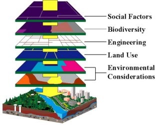
The ability to map layers of data (physical, biological, social, political, economic, ...etc.) is becoming a vital skill for almost anyone.
Learn how to engage in real-world problems that affect the globe and the individuals who are nested within. Aside from learning how to make maps and visualize dynamic social and environmental phenomena, students will learn how to structure, cluster, and summarize spatial data.
Introduction to GIS (Geographic Information Systems)
Mapping and Geospatial Technologies
ENVA Y294-001
MWF 1:30 - 2:20 pm
A Science in Context Loyola Core Course; Pre-Requisites - Investigating Nature or permission from instructor.
Dr. Lynn Brien
for info contact Dr. Brien at lfbrien@loyno.edu